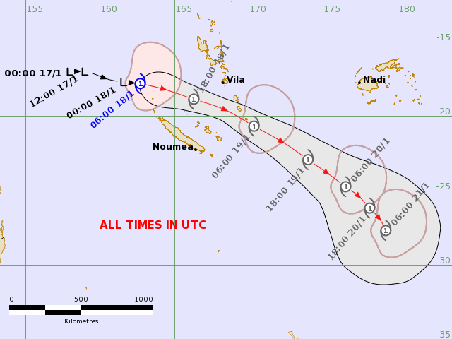
A tropical depression system that entered Fiji’s region today has developed into a tropical cyclone of category one intensity, promptly named TC Irene.
Expected to remain a category one system, as per the latest projections released by the Fiji Meteorological Service (FMS), TC Irene is also anticipated to keep to the initial track outlook, ie, to track over open waters and remain to the south-southwest of Fiji, about 700 kilometres south-southwest of Nadi around 6am on Friday.
Despite the change in intensity forecast, the Fiji weather office says the system will bring with it heavy rain and thunderstorms from tomorrow especially over the Yasawa and Mamanuca groups, Nadi, Lautoka, Ba, Tavua and Rakiraki, Interior Ba and interior Ra, Kadavu, Beqa and Vatulele as well as the Bua and eastern Macuata provinces.
A Heavy Rain Alert has been issued for these areas and showers are expected to increase and become more frequent over these areas from tomorrow afternoon. Strong and gusty winds are expected from tonight over Yasawa and Mamanuca Waters, Southwest Viti Levu Waters and Kadavu Passage. A Strong Wind Warning has been issued for these waters.
The system is being jointly monitored by the Fiji Met Office and the Fiji National Disaster Management Office (NDMO).
Given the forecast and alerts issued by the FMS, Fiji NDMO Director Ms. Vasiti Soko confirmed that the National and Divisional Emergency Operations Centers have been activated as they work closely with the Fiji Met Services in monitoring the current weather situation.
“The NDMO continues our call for the general public to prepare their households and communities accordingly. While this system may pose some direct threats yet to Fiji, members of the public are strongly urged to adhere to advisories issued by authorities and prepare early,” Ms Soko said.
“With coastal inundation also expected from Friday, we urge Fijians living along coastal communities to be vigilant and remain on high alert. Refrain from undertaking any recreational marine activity as hazardous breaking waves and strong currents are expected – posing a peoples’ lives. Mariners are also strongly advised to heed the advisories issued by authorities as sea conditions could be dangerous for small boats due to large waves and rough seas,” she added.
Ms Soko is also advising the general public that with already heavily saturated soil as a result of continuous heavy rain in the past week, the risk of landslides occurring remains.
“Localised heavy falls may also lead to flash flooding of low-lying and flood-prone areas. Members of the public residing in these areas are advised to take the necessary precautionary measures and continue to stay-up-date with the latest weather information and advisories issued by authorities.”
King Tide on Sunday, 22 January
The FMS is also advising the general public to be on alert as the highest tide of the year or the “King Tide” is anticipated this Sunday, January 22.
Coastal Flooding – 20-24 January
Coupled with the effects of wind-driven waves expected from TD05F, particularly from the 20th to the 24th, there is a “high risk” of coastal flooding over coastal areas of Yasawa and Mamanuca groups, western Viti Levu to Coral Coast, Kadavu and nearby smaller islands, Moala Group, Central and Southern Lau Group
.
There is a low to moderate risk of coastal flooding for the rest of Fiji’s coastal areas.
")